The first (known) geological map
By Rebecca Williams

Google ‘the first geological map’ and what results do you get? All but one of the websites returned on the first page talk about William Smith’s pioneering map of England, Wales and Part of Scotland, published in 1815. This was indeed a significant and noteworthy achievement. It was the first geological map of Britain, and the first geological map of an entire nation. It was systematically created, used fossils to correlate formations, and laid the principles for many geological surveys and maps worldwide. An important step in the discipline of geology, and certainly warrants a place on any course on geological mapping.
But it wasn’t the first geological map created. As noted in this Scientific American blog, the idea of depicting the distribution of rocks on a topographic map didn’t materialize out of nowhere. Of note is Count Luigi Ferdinando Marsili’s work “Treatise on the Structure of the Earthy Globe”1. However, the Eurocentric history of the geological map detailed here, and in scholarly articles2,3 only goes back to 1556 and Agricola’s “De re metallica” textbook and it’s chapter on noting the distribution of valuable rocks in the Earth’s crust.
The Turin Papyrus Map
The world’s oldest surviving geological map predates even Agricola’s work by ~2700 years. This map is the c.1150 B.C. Turin Papyrus from Egypt4,5, drawn during the reign of Ramesses IV (1151-1145 B.C). The map is of Wadi Hammamat in the mountains of the central Eastern Desert of Egypt and depicts sedimentary and igneous/metamorphic rocks, gold-bearing quartz veins, the bekhen-stone quarry and gravels. Bekhen-stone was an important resource in the time of the Pharoahs, and used as a stone for high-quality sculptures. It is thought that the map was created by Amennakhte, the chief scribe of the royal necropolis as a commemoration of a pharaonic expedition to the bekhen-stone quarry4.

The map itself is intertwined with colonialism and the extractive processes of archaeologists and colonisers. The map was found by Bernardino Drovetti in the Amennakhte’s family tomb in Deir el-Medina in around 1820. It was removed from the tomb and extracted from Egypt. It is now in the Egyptian Museum in Turin, Italy. Drovetti served in Napoleon’s Egyptian campaign as Consul-General and used this position to acquire significant quantities of Egyptian cultural items. These collections were sold and formed the basis of the Egyptian museums in Turin, the Louvre and Berlin. Drovetti appears to have started something of a collection competition and the rapid growth in large-scale removal of antiquities from Egypt7. That is until Mohamed Ali commenced controls on the export of antiquities from Egypt, at the urging of Rifaat al-Tahtawi. By then though, much of the damage had been done and with the rise of Egyptology as a western discipline through the collections now housed in Europe, indigenous Egyptian scholars were prevented and excluded from researching their own history8. For those of you here because you’re interested in general topics of decolonising academic subjects, you might be interested in this blog by Chris Naunton on decolonising Egyptology.
The first (known) geological Map infographic
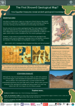
We have created an infographic on the Turin Papyrus map – available here. Next time you are teaching geological mapping, the history of geology, or economic geology include this as a resource. Let’s stretch our history of geological mapping beyond Europe and Smith. Challenge students to consider how and why geology was mapped throughout human history. It can serve as a discussion point on the lesser-known long history of geology, and perhaps why this history is not as known or celebrated as the work of Smith. The Turin Papyrus Map is an interesting example of the cultural importance of geology, with the Behken-Stone being highly prized and important in Ancient Egypt, as well as economic importance. Geological mapping of the 18th, 19th and 20th centuries was driven by economy and the search for resources to industrialise Europe – you can read about how it became an essential tool in colonialism in our earlier blog Telling Stories of the Hidden Colonial Histories of Our Geological Institutions and in this article on geological mapping and land dispossession. Arguably, it still is a colonial practise today but that’s a subject for a future blog.
References
- Romano, Marco, Richard L. Cifelli, and Gian Battista Vai. “The first geological map: an Italian legacy.” Italian Journal of Geosciences 135.2 (2016): 261-267.
- Ireland, H. Andrew. “History of the development of geologic maps.” Bulletin of the Geological Society of America 54.9 (1943): 1227-1280.
- Oldroyd, David. “Maps as pictures or diagrams: The early development of geological maps.” Rethinking the fabric of geology 502 (2013): 41-101.
- Harrell, James A., and V. Max Brown. “The World’s oldest surviving geological map: the 1150 BC Turin Papyrus from Egypt.” The Journal of Geology 100.1 (1992): 3-18.
- McMahon, David M. “The Turin Papyrus Map the oldest known map with geological significance.” Earth Sciences History 11.1 (1992): 9-12.
- Weiss, Daniel, et al. “Mapping the Past.” Archaeology, vol. 72, no. 3, 2019, pp. 26–33. JSTOR,
- https://www.ucl.ac.uk/museums-static/digitalegypt/museum/museum5.html
- Reid, Donald M. “Indigenous Egyptology: The Decolonization of a Profession?” Journal of the American Oriental Society, vol. 105, no. 2, 1985, pp. 233–46. JSTOR


